Hamburg Transit Maps
Public Transport Network Maps for Hamburg. Offline. Reliable. Fast.
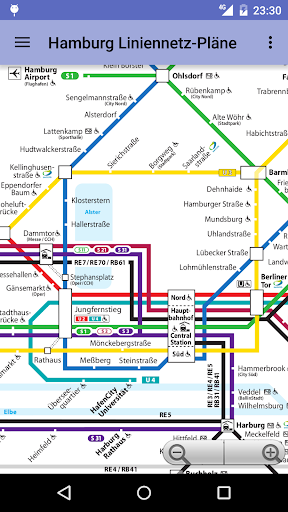


Hamburg Transit Maps - Offline Transport Maps
"Hamburg Transit Maps" is an essential Android app that keeps the public transport maps of Hamburg at your fingertips. It includes plans for Schnellbahn, Metrobus (Overview), Metrobus (All stations), and Tarife, enabling you to navigate the city's transport system quickly and reliably, even without an internet connection. Perfect for commuters and tourists alike, this app ensures you're always prepared to explore Hamburg's extensive transport network.
App stats
By: Topobyte.de
Permissions:
- android.permission.ACCESS_NETWORK_STATE
- android.permission.INTERNET
- com.android.vending.BILLING
- de.topobyte.transportation.plan.deu.hamburg.DYNAMIC_RECEIVER_NOT_EXPORTED_PERMISSION
Size: 6.36M
Email: se*****@fu-berlin.de
URLs: Website ,Privacy policy
Full description: See detailed description
Source: Google Play Store
Ranking
User reviews
Offers all transportation maps needed when roaming through Hamburg. Quick access and easy to use. My recommendation. A must have when using public transportation.
by  A Google user, 2016-05-23
Similar apps
Here are some Android apps that are similar to Hamburg Transit Maps:

AppPlay Software
214 0.00  (0)
(0)

MobiTech Digital Ltd
4K 0.00 (0)

Sklr
1K 0.00 (0)

Topobyte.de
28K 0.00 (0)

CityMaps2Go-Kulemba
18K 0.00 (0)

dieEinsteiger
99K 0.00 (0)

Mapway
82K 0.00 (0)

Map Apps
26K 0.00 (0)

Topobyte.de
109K 0.00 (0)