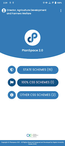
Planspace 2.0

Mobile App based field-level physical progress Mapping with Geo Tagging
"Planspace 2.0" is an advanced mobile app developed by the Government of Kerala for field-level mapping of physical progress and geo-tagging of over 1900 plan schemes and projects. Integrated with intelligent analytics, it empowers officials to track and evaluate the lifecycle of various schemes implemented across the state. Launched in FY 2022-23, this app enhances governance efficiency and transparency, making it a vital tool for informed decision-making and progress monitoring in public projects.
Downloads:
2,818 11
Version:
7.0 (Last updated: 2024-07-10)
Full description:
See detailed description
Updated:
a day ago

Similar apps

Here are some Android apps that are similar to Planspace 2.0:

Geoplanning Mobile Geoplanning Mobile
Actia Telematics Services
215 0.00 (0)
R&D Field R&D Field
NTCPWC
- 0.00 (0)
MIS Field MIS Field
NTCPWC
1 0.00 (0)
PlanGlobal PlanGlobal
Sferion
26 0.00 (0)
MIRS Field MIRS Field
NTCPWC
2 0.00 (0)
Planimeter: Field Area Measure Planimeter: Field Area Measure
CA40
272K 4.55 (1,041)
Field Survey & Work Monitoring Field Survey & Work Monitoring
My Property QR
159 0.00 (0)
myPlan.cloud 3 myPlan.cloud 3
Bit Different Kft.
22 0.00 (0)
ALHW Field ALHW Field
NTCPWC
15 0.00 (0)